Look at the Mandalay Canal from two levels
Pair a short canal-side visit with a look at how Las Colinas streets meet the water.
In this article
The Mandalay Canal gives Las Colinas two views of the same busy blocks. From the street, a visitor can read the frontages, crossings and approaches around Irving’s Urban Center. At the water, the view takes in bridge undersides, shorter stretches of walkway and building faces that might have been hidden from above. Pairing the two levels makes the canal easier to understand, even if you spend only a short time on the lower path. Pick a public meeting spot and check the connection between the levels before trying to make a loop.
The Las Colinas Association venue listing places the canal at 215 Mandalay Canal. Visit Irving’s account describes the waterway as Venice-inspired, connected to Lake Carolyn and part of Ben Carpenter’s larger plan for the Urban Center. It identifies a mix of hotels, shops, restaurants, offices and residences along the route. The distinction between a street approach and a water approach is central to how those uses fit around the canal.
Find the water from an ordinary street approach
Start with a public arrival point you can describe to another person. Use the published location and look for a street name, building address or recognizable public sign near the approach. Confirm where the rest of your group can meet and whether that place is on the upper street level or beside the water. The words “by the bridge” can point to more than one level. A meeting instruction that names the level and the public approach gives people a way to find each other without expecting them to know the whole canal first.
Before changing levels, look at how the canal is framed by buildings. See whether a space in the street line gives the first view of the water or whether you only see it once you approach a bridge. A person looking out from a passing vehicle, another walking toward an office and somebody heading down to the canal are all likely to notice different things. From a public approach, identify the first point where you can tell how far the water lies below the building or street beside it. Keep walking past a busy crossing before stopping to spend time on the view.
Observe the canal and Lake Carolyn as related spaces
Visit Irving’s history describes how the lake and canal became part of the same Las Colinas development. The Las Colinas Association's architecture tour recap puts the water and surrounding buildings in the context of the development’s architectural and economic history. Read those accounts before assuming the streets followed a natural channel. What is visible today is a planned relationship between water, structures and the ways people arrive. Compare a long view toward Lake Carolyn with a much tighter view along part of the built canal.
From a suitable public viewpoint, see how the width of the water shapes what you can take in. A relatively narrow canal view organizes attention toward the next bridge, bend or facade. A wider opening can bring more of the sky and surrounding buildings into view. You do not need to walk all the way to the lake to make a useful observation. Orient yourself with the map and mark which direction it lies in. If a passage is closed or access is unclear, keep the rest of the visit on the part of the network you have verified.
Compare a bridge at street and water height
Choose a public bridge or crossing where the design can be observed without interrupting somebody’s route. From the upper level, notice what your eye follows across the span. It could be a railing, the street edge or a view straight down the canal. If you find a suitable public route to the water, look at how much of the same bridge shows up from below. The arch can act as a frame for the next part of the walkway, while from above the bridge may look like one step in a larger street route.
The short comparison also shows why orientation changes. A building entrance that seems close from above can be separated from the lower path by a wall or different door. That does not establish public access inside the building. Follow the signs people are meant to use on each level. If you are meeting for a business appointment, dinner or an event, ask the specific host which entrance belongs to that visit and which route suits the people coming. A landmark can help someone get oriented while a confirmed address and access instruction finish the job.
Watch what changes nearer the water
At the lower level, pick one segment and see what the canal’s edge does. The walkway may approach a bridge or pass a place where the building’s materials change near the water. Notice a particular detail such as where a railing begins, whether a wall changes height or how a facade first appears from the next bend. Reflections can make even small changes in light easy to see. Two people looking at the same stretch can compare which features helped them remember the route and which they only noticed once they had stopped.
The association’s Las Colinas visitor guide describes ways to spend time along the water. Treat a business stop or scheduled activity as another component of the outing with its own current directions. A terrace you can see from the path may be part of a business, and an event’s published entry can be a different route from the one ordinary pedestrians use. Look for the edge between public circulation and an entrance controlled by a venue. Make plans using the venue’s own information if you intend to go through it.
Agree on a usable return before going down
Identify where the lower route meets the upper level on the day you go. A route can have stairs, uneven paving or a different surface from the main sidewalk. One past Las Colinas Association event warned visitors to plan for limited access and varied surfaces along the canal. It is evidence about the conditions the organizer described, while the parking or access plan published for that old event applies to that event. Ask the property, city visitor contact or event operator for current information about the route you need. Las Colinas Association’s archived event guidance
If someone requires a continuous step-free path or a particular drop-off approach, confirm both the outward trip and the return. Do not rely on a shortcut somebody remembers from an earlier visit. It may be unavailable, or it may lead to an entrance for a different use. The upper level can support an outing built around a public vantage point if that is the suitable route. Make that choice before sending everyone to wait by the water. Include a map reference and the name of the confirmed meeting location when you share the plan.
Use a dated image to ask a more precise question
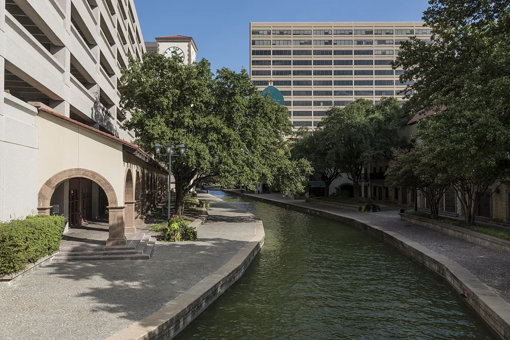
The historical photograph accompanying this guide shows the canal as photographer Carol M. Highsmith saw it. The Library of Congress catalog record identifies the scene as a canal in Las Colinas in Irving. Use the image to orient a question about the everyday scene. It might help you see what fits into a view along a narrow stretch or recognize how closely a building can approach the water. Treat the date as part of the evidence if you notice differences between the image and present conditions.
Pick a detail that would still be meaningful if nobody took a photograph on the current trip. You might describe where the upper street disappears from view as you lower your eye or how the water reflects a building that stands just outside your direct line of sight. If you do take an image, stop somewhere suitable and stay clear of through traffic and doorway movement. Keep the observation separate from a claim about when a feature was installed. Construction plans, the association archive or a dated series of views can address changes to the built setting.
Leave room for the group to choose a shorter version
Give the outing two stopping points. On the first, find a place on an available upper approach where you can see the water or its relation to the adjacent buildings. On the second, when the lower route is suitable, choose one short canal segment. Set a meeting time based on the actual route rather than guessing the distance from a straight line on a map. If the group decides to skip the lower view, talk through how you would reach it from the upper level and what additional information you would need.
Pick one feature that someone else would be able to find on the same trip. It could be the sweep of a bridge from the lower path, the first water view along an upper street or the point where the canal begins to feel connected to the larger lake. Mark the level, direction and a fixed reference. That simple description is more useful for another visitor than a long list of demonstrations or a photo caption without a location. It also gives you somewhere to begin if you return at another time of day to see how light changes the same route.
If a first-time visitor is joining independently, ask them to repeat the agreed meeting level and street back to you. If all they have is the general canal pin, give them the one fixed public landmark you have confirmed and leave the optional lower segment for after everyone arrives.
Find more local visits in the Las Colinas News archive.
Sources
- Las Colinas Association venue listinglascolinas.org
- Visit Irving’s accountirvingtexas.com
- Las Colinas Association's architecture tour recaplascolinas.org
- Las Colinas visitor guidelascolinas.org
- Las Colinas Association’s archived event guidanceanniversary.lascolinas.org
- Library of Congress catalog recordloc.gov